How do abiotic and biotic processes affect the spatial morphology of a landscape and what drives the distribution of species and communities?
Answers to these questions vary across ecosystems and with scale. Selecting an appropriate scale of analysis is fundamental to investigating and understanding the ecological processes that drive landscape morphology, assembly patterns of primary producers, and the spatial distribution of habitats used by consumers of higher trophic levels.
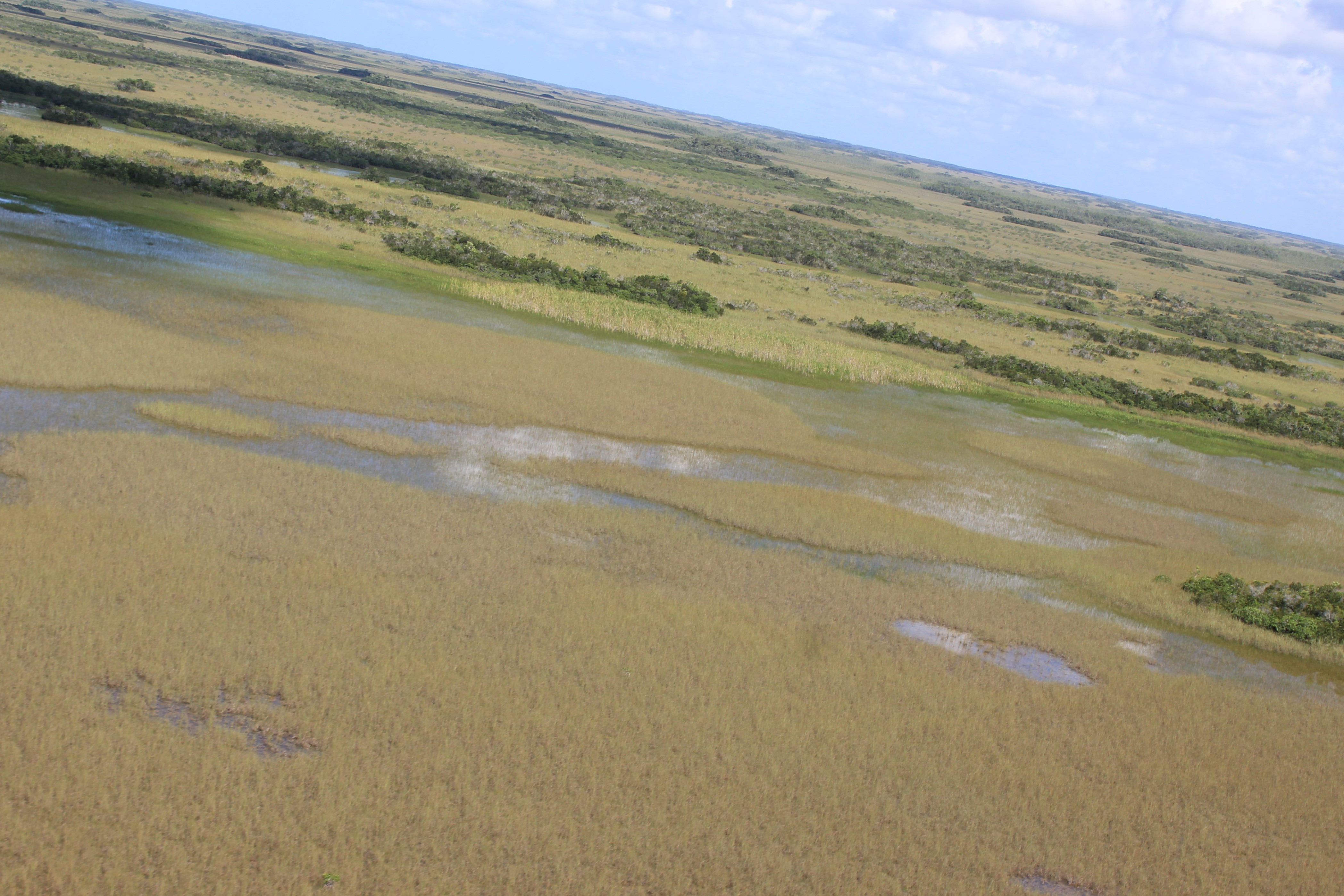
Coastal Wetland Dynamics
Coastal wetlands and their surrounding seascapes are composed of diverse mosaics of ecosystems that offer unique laboratories to study ecological processes that interrelate the marine ecosystems of coral reefs and seagrass beds to coastal mangrove forests and vast terrestrial, graminoid-dominated marshes and prairies, tree islands, and cypress and pine forests.
Our main focus are the coastal ecosystems of South Florida. We aim to better understand ecosystem and plant community shifts in the Everglades landscape mosaic that are driven by changing environmental conditions including interactions of sea-level rise, freshwater management practices and restoration, fire regimes, and passing tropical storm events.
The different processes that operate and interact at different scales across the landscape often require cross-scale and multi-scale modeling of ecological processes and patterns. To understand ecosystem processes and their effects on vegetation transitions across spatial scales, we use very high spatial resolution remote sensing data and scaling algorithms that allow for larger-scale inferences, and prediction at different scales.
Crucial for system-wide scaling are methods that allow for estimation and reduction of information loss. The effects of categorical data scales and scaling of multi-scale quantitative classification systems are the focus of our research.
Research Interests:
(2) Plant Community Transitions:
(a) Glycophytic - Halophytic Community Dynamics in Response to Sea-Level Rise
(b) Effects of Hydroperiod Length and Fire on Spatio-Temporal Dynamics of Freshwater Wetland Communities
(3) Woody and Graminoid Species Co-Existence Patterns in Wetland Ecosystems
Wildlife Habitat Assessment and Conservation
Mobile species moving across the landscape to forage, find mates and reproduce and to avoid predators respond to the the structure of the landscapes across scales. The specific needs of a species determine optimal and suitable habitat. The abundance and spatiotemporal distribution of resources drive decisions of individual at the organism level.
Project 1: Habitat Selection of the St Vincent Parrot (Amazona guildingii)
We are working with the St Vincent department of Forestry to determine optimal habitat for the St Vincent Parrot producing and analyzing landcover maps at various spatal scales using airborne and terrestrial LiDAR technology and associating parrot presence and occupancy times across different landcover and landuse times using passive acoustic monitoring (SWIFT ONE, Cornell Lab).
Projects
Title: Evaluating the effects of hydrological restoration and sea-level rise on vegetation patterns within Everglades National Park (2014 - 2028)
Objectives: We are assessing effects of hydrological restoration, and sea-level rise on vegetation patterns and transition dynamics across the ENP landscape. All project components use very high-resolution remote sensing data and methods to detect and model spatially explicit and exhaustive changes in vegetation/plant communities. Spatially explicit modeling of vegetation change in relation to environmental conditions is conducted in a landscape ecological framework at multiple spatial scales. Subregions of interest are (1) NESRS and TS responses to hydrological restoration; (2) Mangrove encroachment patterns in the coastal regions of Eveglades National Park; (3) Vegetation dynmaics in Shark-Harney River Network oin response to coastal creek expansion; (4) Woody vegetation distribution patterns and their environmetnal and spatial drivers.
Funded by: Everglades National Park
Lead PIs: Dr. Daniel Gann, Dr. Jennifer Richards
Title: Evaluating the effects of fire history on coastal marsh peat collapse features in the northwest coastal Everglades, Everglades National Park (2023 - 2028)
Objective: We are assessing what effect, if any, fire has on coastal marsh peat collapse and in the number and size of collapse features within the landscape. The project uses remote sensing techniques to determine if peat collapse features within the coastal Everglades are increasing in number and size following fires.
Funded by: Everglades National Park
Lead PIs: Dr. Daniel Gann
Title: Modeling and Correcting Vegetation-Induced Bias for LiDAR-Derived Digital Terrain Models in Water Conservation Areas (2021 - 2027)
Objective: Improve developed filtering and interpolation algorithms to estimate and correct vegetation class-specific biases and produce accurate DTMs from raw LiDAR point clouds from newly acquired LiDAR data and to model elevation bias of DTMs introduced by vegetation. The objective is to model the elevation bias introduced by 12 morphologically different woody and herbaceous vegetation classes: (1) Woody classes: hardwood hammock trees, bayhead trees, cypress trees, bayhead shrubs, and dwarf cypress; (2) herbaceous classes: tall and dense graminoid marsh species (including Cladium, Typha and other tall grasses and sedges), and short graminoid marsh, prairie communities, open marsh with sparse floating and emergent vegetation, and floating vegetation. All classes are mapped from spectral reflectance patterns of the WV-2 or -3 and/or PlanetScope multispectral satellite data to inform the bias estimation and adjustment models.
Funded by: South Florida Water Management District
Lead PIs:Dr. Daniel Gann, Dr. Jed Redwine
Title: Tree Island Ground Topography in Relation to Changes in Marsh Hydrology - Water Conservation Area 3 Tree Island Surveys of High-Accuracy Elevation, Soil and Vegetation (2025 - 2028).
This project has three specific objectives:
- Estimate the relative elevation and spatial distribution of woody vegetation components of each tree island > 0.01 ha in WCA3A and 3B.
- Quantify past distributions of hydrological conditions among plant communities of interest across all sampled tree islands and non-sampled islands and compare tree islands within and among regions.
- Quantify the spatial dependence of plant community distributions of tree islands as a function of biophysical parameters such as, island location distance to control structures, community cover along relative elevation distributions, and soil type and depth. The rationale for this objective is that the relationship between physical environmental variables and woody vegetation distributions are expected to vary spatially (e.g., due to different nutrient availability, biological processes, and succession legacies of community assembly).
Funded by: South Florida Water Management District
Lead PIs:Dr. Daniel Gann, Dr. Jed Redwine
Title: Florida Coastal Everglades Long-Term Ecological Research (FCE-LTER) (2025 - 2030)
Objective: The central focus of the Florida Coastal Everglades (FCE) Long Term Ecological
Research program is to understand the mechanisms and consequences of resilience in socialecological systems to shifting climate and hydrologic disturbance regimes.
Funded by: National Science Foundation
Lead PIs: Dr. John Kominoski, Dr. Daniel Gann, Dr. Jennifer Rehage, Dr. Rolando Santos, Dr. Tiffany Troxler
Title: Monitoring, Modeling and Assessment of the Everglades Ecosystem: R-EMAP V (2023 - 2026)
Objective: The overarching objectives of REMAP are to measure the condition of ecological resources throughout the Everglades and to document ecosystem responses as CERP restoration efforts change the quality, quantity, timing, and distribution of water, while Florida also implements control strategies for pollutants such as phosphorus and mercury. REMAP is unique to the Everglades in consistently combining several aspects of scientific study: a probability-based sampling design which results in quantitative statements about the condition of the Everglades across space, multi-media biogeochemical sampling (water, soil, biota), and extensive spatial coverage of the freshwater Everglades.
Funded by: Everglades National Park & Environmental Protetion Agency
Lead PIs:Dr. Daniel Gann, Dr. Yong Cai, Dr. Yan Ding, Dr. Guiangliang Liu, Dr. Paulo Olivas, Dr. John Kominoski, Dr. Jed Redwine
Title: Restoring Historical Flows in the Water Conservation Areas (2025 - 2028)
Objective: The project assesses the use of ground-penetrating radar (GPR) as tool for imaging belowground root distribution and to test whether aboveground biomass abundance can predict belowground root biomass across Everglades plant communities.
Funded by: South Florida Water Management District
Lead PIs:Dr. Jed Redwine, Dr. Xavier Comas, Dr. Daniel Gann
Title: Vegetation Distribution in Biscayne Bay Coastal Wetlands - Remote Sensing Methods Development (2025)
Objective: The objective of this research project is to develop a method to detect and model major vegetation shifts in the Biscayne Bay Coastal Wetlands using multi-spectral satellite, and airborne lidar data.
Funded by: South Florida Water Management District
Lead PIs: Dr. Brittany Harris, Dr. Daniel Gann, Dr. Michael Ross
Title: Assessment of Upland Resources within Miami Dade County (2025 - 2026)
The purpose of the project is to assist Miami Dade County’s Division of Environmental Resources Management (DERM) in assessing upland resources within the county. The project will assess 250 tree plots and integrate the plots in a LiDAR driven tree canopy model and provide evaluations of potential environmentally sensitive footprints.
Funded by: Miami-Dade County
Lead PIs: Dr. Daniel Gann, Dr. Brittany Harris, Dr. Dishane Hewavithana, Dr. Tiffany Troxler
Title: Tree Island Dynamics in Everglades National Park (2024 - 2029)
Objectives: The specific objectives of the proposed work are to (1) monitor the condition of plant community structure and composition of tree islands; (2) to assess temporal changes in the plant community structure and composition; (3) to determine the relationships among the hydrologic regimes of adjacent marshes, other stress variables, and dynamics of vegetation communities on tree islands; and (4) to investigate the correlation of spatially explicit long-term vegetation changes in response to hydrological regime changes.
Funded by: U.S Army Corps of Engineers
Lead PIs: Dr. Jay Sah, Dr. Daniel Gann, Dr. Michael Ross
Title: Tree island response to hydrologic and fire regime changes in Northeast
Shark River Slough (NESRS), Everglades National Park (2024 - 2028)
Objective: The major objectives are to determine the hydrologic optima of tree island woody species and assess the impacts of hydrologic restoration on them in NESRS and to assess how tree islands physiography in NESRS has changed between 1940 and present
in response to hydrologic management, fire regime, and invasive species.
Funded by: Everglades National Park
Lead PIs: Dr. Jay Sah & Dr. Daniel Gann
Title: Exploring Human-Wildlife Interconnectivity in the Caribbean – A Hands-On Approach to Research, Conservation and Professional Development (2024 - 2027)
Objective: This international training program, spearheaded by the Institute of Environment (IoE) at Florida International University in collaboration with St. Vincent and the Grenadines' Departments of Forestry and Fisheries, Science Initiative for Environmental Conservation and Education (SCIENCE, partner NGO), and the Barrouallie Whalers Project (partner NGO), aims to offer exceptional research and professional development opportunities in Wildlife Conservation and Ecology to U.S. undergraduate and graduate students. Each year, we recruit six students (2 two graduates and four undergraduates) for a comprehensive year-long research program investigating human-wildlife interactions involving terrestrial and marine flagship species. The program features a pivotal four-week fieldwork experience in St. Vincent and the Grenadines (SVG), in the eastern Caribbean. During field activities, students will receive hands-on mentorship from SVG's Forestry and Fisheries Department, along with research and capacity-building training from the project’s PIs.
Funded by: National Science Foundation
Lead PIs: Dr. Jeremy Kiszka & Dr. Daniel Gann
Title: MRI: Development of an instrument for student and faculty research on Multimodal
Environmental Observations (2020 - 2026)
Funded by: National Science Foundation
Lead PIs: Dr. Naphtalie Rishe, Dr. Daniel Gann, Dr. Shahin Vasigh, Dr. Sitharama Iyengar, Dr. Todd Crowl
Publications & Datasets
To view all publications, please visit Dr. Daniel Gann's Google Scholar site.